Dambulla City
Journey into the heart of cultural splendor in Dambulla, where ancient history meets modern exploration. Uncover the marvels of the UNESCO-listed Dambulla Cave Temple, meander through vibrant markets, and savor the unique fusion of tradition and innovation in this enchanting Sri Lankan town.
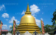
ダンブッラ黄金寺院
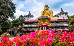
ダンブッラの黄金寺院としても知られるダンブッラ石窟寺院は、スリランカの中部に位置し、世界遺産 (1991 年) に登録されています。この場所は、コロンボの東 148 キロ (92 マイル)、キャンディの北 72 キロ (45 マイル)、マータレーの北 43 キロ (27 マイル) に位置しています。
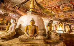
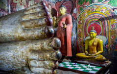
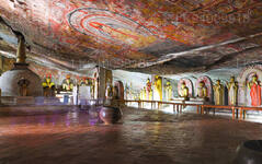
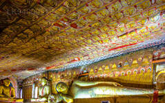
ダンブッラは、スリランカ最大で最も保存状態の良い石窟寺院群です。この岩は周囲の平野の上に 160 メートルそびえ立っています。周囲には80以上の洞窟が記録されています。主要な見どころは 5 つの洞窟に広がっており、そこには彫像や絵画が収められています。これらの絵画や彫像はゴータマ・ブッダとその生涯に関連しています。スリランカ王の像 3 体、神と女神の像 4 体の合計 153 体の仏像があります。後者にはヴィシュヌ神とガネーシャが含まれます。壁画は 2,100 平方メートル (23,000 平方フィート) の面積をカバーしています。洞窟の壁には、悪魔マーラによる誘惑や釈迦の最初の説教などが描かれています。
ダンブッラ洞窟群の近くのイバンカトゥワにあるこの地域には、約 2700 年前の人骨のある埋葬地があるため、先史時代のスリランカ人はスリランカに仏教が伝わる前にこれらの洞窟群に住んでいたと考えられます。
この寺院群の歴史は紀元前 1 世紀にまで遡ります。突き出た広大な岩の下に 5 つの洞窟があり、内部を乾燥に保つために点滴ラインが刻まれています。 1938 年に、この建築はアーチ型の列柱と切妻の入り口で装飾されました。洞窟内の天井には、岩の輪郭に沿った宗教的なイメージの複雑なパターンが描かれています。仏陀や菩薩、さまざまな神や女神の像があります。
ダンブッラ石窟修道院は今も機能しており、スリランカで最も保存状態の良い古代建造物です。この複合施設は紀元前 3 世紀から 2 世紀に遡り、すでに最大かつ最も重要な修道院の 1 つとして確立されていました。アヌラーダプラのヴァラガンバは伝統的に、紀元前 1 世紀に洞窟を寺院に変えたと考えられています。アヌラーダプラから追放された彼は、南インドの簒奪者から 15 年間ここに避難しました。首都を取り戻した後、王は感謝の礼拝のために神殿を建てました。その後、他の多くの王が洞窟を追加し、11 世紀までに洞窟は主要な宗教の中心地となり、今でもその存在となっています。ポロンナルワのニッサンカ マーラは、1190 年に洞窟に金メッキを施し、約 70 体の仏像を追加しました。18 世紀に、キャンディ王国によって洞窟が修復され、塗装されました。
ダンブッラ寺院群の保存活動は主に壁画の保存に重点を置いています。 Senake Bandaranayake は、壁画の洗浄と保護コーティングの塗布を含む 1960 年代の初期の保存プロジェクト中にこの計画が洗浄されたと報告しています。
ダンブッラ寺院群におけるその後の保存戦略 (主に 1982 年以降) は、1930 年代に寺院のベランダが再建されて以来、変更されずに残っている既存の寺院群の完全性を維持することに焦点を当ててきました。この戦略は、1982 年から 1996 年まで実施されたユネスコ、スリランカ文化トライアングル プロジェクト、ダンブッラ神殿当局の間の共同プロジェクト中に合意されました。
About Matale District
Matale is a town in the hill country of Sri Lanka. The Knuckles Mountain Range is a special landmark of Matale.The Matale administrative district also contains the historic Sigiriya rock castle, Aluvihare Temple and Dambulla Cave Temple . Surrounding the town are the Knuckles foothills called Wiltshire. It is a mainly agricultural area, where tea, rubber, vegetable and spice cultivation dominate.
The Aluvihare Temple, on the North side of the town, is the historic location where the Pali Canon was first written down completely in text on ola (palm) leaves. Situated near Aluvihare are numerous monastery caves, some of which exhibit fine frescoes.
About Central Province
The Central Province of Sri Lanka consists primarily of mountainous terrain. The province has an area of 5,674 km², and a population of 2,421,148. Some major towns include Kandy, Gampola (24,730), Nuwara Eliya and Bandarawela. The population is a mixture of Sinhalese, Tamil and the Moors.
Both the hill capital Kandy and the city of Nuwara Eliya are located within the Central Province as well as Sri Pada. The province produces much of the famous Ceylon tea, planted by the British in the 1860s after a devastating disease killed all the coffee plantations in the province. Central Province attracts many tourists, with hill station towns such as Kandy, Gampola, Hatton and Nuwara Eliya. Temple tooth or Dalada maligawa is the main sacred place in Centrel province.
The climate is cool, and many areas about 1500 meters often have chilly nights. The western slopes are very wet, some places having almost 7000 mm of rain per year. The eastern slopes are parts of the mid-dry zone as it is receiving rain only from North-Eastern monsoon. The Temperatures range from 24°C at Kandy to just 16°C in Nuwara Eliya, which is located 1,889 m above sea level. The highest mountains in Sri Lanka are located in the Central Province. The terrain is mostly mountainous, with deep valleys cutting into it. The two main mountain regions are the central massif and the Knuckles range to the east of Kandy.

