Pottuvil City
Pottuvil, a charming coastal town in Eastern Sri Lanka, is famous for its stunning beaches and laid-back atmosphere. Just a stone's throw from the renowned surfing destination of Arugam Bay, Pottuvil offers pristine sands and turquoise waters, perfect for surfing, swimming, and sunbathing. The town is also a gateway to the Kumana National Park, known for its rich biodiversity and birdwatching opportunities. With its blend of natural beauty and relaxed vibe, Pottuvil is an ideal destination for beach lovers and nature enthusiasts seeking a tranquil escape.
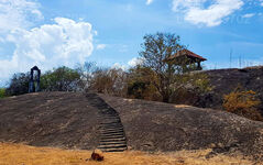
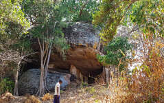
サストラウェラ マニ ナーガ パバタ ヴィハラヤ
現在、サストラウェラ村はパナマ・ポットゥビル道路沿いに位置する小さな居住地となっている。この村は調査将軍の地図にも載っていない。 1980年代以来、地域の騒乱のため住民の多くがパナマに避難した。しかし、ルフヌ王国の干し草の時代には、サストラウェラはよく知られていただけでなく、重要な学問の地とも考えられていました。民間伝承によると、サストラウェラという名前は元の名前シャストラウェイリヤに由来していると言われており、この地域が学習機関と関連していたことを示しています。 「シャストラ」という言葉は、大まかに言っても学問や芸術形式を意味します。この地域は古代、多くの占い師や学者が住んでいたと言われています。伝説によれば、遠く離れた王国から、さらには海の向こうのインドから学者たちが科学や占星術のさまざまな分野を学ぶためにサストラウェラを訪れたと言われています。
About Ampara District
Amparais belongs to the Eastern Province of Sri Lanka. It is a remote city on the East Coast of Sri Lanka, about 360 km from the capital city ofColombo. Ampara is the largest paddy harvesting province in the country, and has the Indian Ocean on the east coast of Sri Lanka as a fisheries resource. Most of the civilians are Sinhala, while Tamils and Sri Lankan Moors also live in the coastal parts of the district.
About Eastern Province
The Eastern Province is one of the 9 provinces of Sri Lanka. The provinces have existed since the 19th century but they didn't have any legal status until 1987 when the 13th Amendment to the 1978 Constitution of Sri Lanka established provincial councils. Between 1988 and 2006 the province was temporarily merged with the Northern Province to form the North-East Province. The capital of the province is Trincomalee. The Eastern province's population was 1,460,939 in 2007. The province is the most diverse in Sri Lanka, both ethnically and religiously.
Eastern province has an area of 9,996 square kilometers (3,859.5 sq mi).The province is surrounded by the Northern Province to the north, the Bay of Bengal to the east, the Southern Province to the south, and the Uva, Central and North Central provinces to the west. The province's coast is dominated by lagoons, the largest being Batticaloa lagoon, Kokkilai lagoon, Upaar Lagoon and Ullackalie Lagoon.


