Dambulla City
Journey into the heart of cultural splendor in Dambulla, where ancient history meets modern exploration. Uncover the marvels of the UNESCO-listed Dambulla Cave Temple, meander through vibrant markets, and savor the unique fusion of tradition and innovation in this enchanting Sri Lankan town.
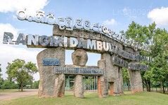
ランギリ ダンブッラ国際スタジアム ダンブッラ
ランギリ ダンブッラ インターナショナル クリケット スタジアム ダンブッラ
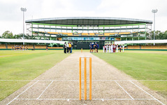
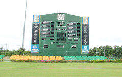
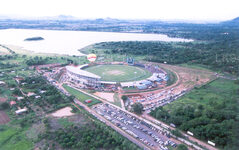
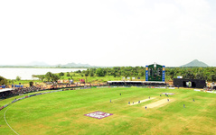
ランギリ ダンブッラ国際スタジアムは重要なクリケット場です。敷地はランギリ ダンブッラ寺院から借りた 60 エーカーの土地全体に拡張されています。グラウンド建設の背後にあるアイデアは、年間を通してワンデイマッチを開催できる会場を提供することでした。建設にはわずか 167 日しかかかりず、2000 年に正式に開門しました。
歴史
建設にはスリランカ・クリケット管理委員会(BCCSL)が資金提供し、当時のBCCSL会長ティランガ・スマティパラが支援した。建設にかかった日数はわずか 167 日でした。建設と初戦の後、リース契約と請負業者との複雑な問題により、活動は休止状態となった。国際クリケットは 2003 年 5 月にようやく再開されましたが、南部ではモンスーンの雨が降っていたため、この会場でトーナメントの 7 試合すべてが開催されました。
- ワンデイ インターナショナル (ODI) の第 1 回試合は、2001 年 3 月にスリランカとイングランドの間で行われました。
- 投光器は 2003 年に設置されました。
- 2011 年クリケット ワールド カップに向けて他のグラウンドが改修されたため、このスタジアムは 2010 年アジア カップの全試合が開催されました。
- このスタジアムでは、2013 年から 2016 年末までデーマッチのみが開催されました。
位置
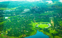
ランギリ ダンブッラ国際スタジアムは、スリランカ北中部州、ダンブッラ近くにあります。グラウンドは乾燥地帯にあります。ダンブッラ タンク (貯水池) とダンブッラ ロックを見渡せます。この国の乾燥地帯に属します。
ピッチについて
このグラウンドのピッチは、地下水面が高い午前中はシーマーに、そして崩れる可能性がある午後にはスピナーに心地よい土壌を提供するため、ボウラーの最初の選択肢と考えられています。
About Matale District
Matale is a town in the hill country of Sri Lanka. The Knuckles Mountain Range is a special landmark of Matale.The Matale administrative district also contains the historic Sigiriya rock castle, Aluvihare Temple and Dambulla Cave Temple . Surrounding the town are the Knuckles foothills called Wiltshire. It is a mainly agricultural area, where tea, rubber, vegetable and spice cultivation dominate.
The Aluvihare Temple, on the North side of the town, is the historic location where the Pali Canon was first written down completely in text on ola (palm) leaves. Situated near Aluvihare are numerous monastery caves, some of which exhibit fine frescoes.
About Central Province
The Central Province of Sri Lanka consists primarily of mountainous terrain. The province has an area of 5,674 km², and a population of 2,421,148. Some major towns include Kandy, Gampola (24,730), Nuwara Eliya and Bandarawela. The population is a mixture of Sinhalese, Tamil and the Moors.
Both the hill capital Kandy and the city of Nuwara Eliya are located within the Central Province as well as Sri Pada. The province produces much of the famous Ceylon tea, planted by the British in the 1860s after a devastating disease killed all the coffee plantations in the province. Central Province attracts many tourists, with hill station towns such as Kandy, Gampola, Hatton and Nuwara Eliya. Temple tooth or Dalada maligawa is the main sacred place in Centrel province.
The climate is cool, and many areas about 1500 meters often have chilly nights. The western slopes are very wet, some places having almost 7000 mm of rain per year. The eastern slopes are parts of the mid-dry zone as it is receiving rain only from North-Eastern monsoon. The Temperatures range from 24°C at Kandy to just 16°C in Nuwara Eliya, which is located 1,889 m above sea level. The highest mountains in Sri Lanka are located in the Central Province. The terrain is mostly mountainous, with deep valleys cutting into it. The two main mountain regions are the central massif and the Knuckles range to the east of Kandy.

