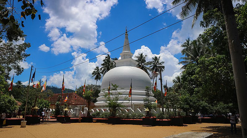
Badulla City
Badulla: Scenic town in Sri Lanka's hill country, surrounded by lush tea plantations and offering picturesque landscapes, waterfalls, and cultural sites.
ナランガラ
黄金色の芝生が美しいナランガラは、スリランカのウバ県にある高さ 1500 メートル以上にそびえ立っています。ウバ島で 2 番目に高いこの山の頂上からは、熱帯の島全体で最高の景色を眺めることができます。それに加えて;適度な挑戦を伴う登山は、ハイカーの間で非常に人気があります。
ハイキングスポット: ナランガラ山頂
高さ: 1527m
難易度: 中
服装:グリップ力のある登山靴、暖かい服装
持ち物:水筒、エナジーバー、虫除けスプレー
ルートの説明:
ハイキング コースはタンガマライ エステート地区から始まります。名前は文字通りタミル語で「黄金の山」を意味し、ナランガラの斜面を覆う黄金の草に由来しています。ナランガラの最も特徴的な特徴の 1 つは、その尖った長方形の頂上であり、遠くからでも非常に魅力的な光景です。
ハイカーは敷地内のヒンズー教寺院に車を停めてください。ガイドが同行していない場合は、地元の人々が喜んで案内を手伝ってくれます。茶園に水を供給する大きなパイプラインを見つけるまで、茶園内の小さな歩道を登る必要があります。次に、ポイントハットが敷地内を通る道路に到達するまでパイプをたどります。茶の木の明るい緑に覆われた斜面の美しい景色がたくさんあります。写真を撮ることができるもの。しばらく団地道を進むと登山口に到着します。
登りの最初の部分はテレピン油の木立の中を通ります。これらの木から落ちた葉は非常に滑りやすいです。地面の傾斜が増し、足場が非常に危険になります。ナランガラの斜面の黄金色の草の中をハイキングするのは、のどかな雰囲気ですが、
それらに到達する難しさを補います。時折、野生動物とその足跡が見られます。だから彼らの邪魔をしないようにしてください。頂上に到達する前に、素晴らしい景色を望むナランガラの下層山を 4 つ越えます。
目の前に広がる景色は圧巻です。ウマ オヤ川、バドゥル オヤ川、ロッガル オヤ川の谷間を眺めることができます。トリンコマリーまで続くマハウェリの氾濫原を鷲の目で眺めながら。遠くにあるケヘルパスドルワ山脈とヤハナガラ山脈も見られます。ナヤベッダ山脈、マドゥルシマ山脈、プーナガラ山脈。イダルガシナギャップとハプタレーギャップ。ランデニガラの斜面とホートン平原のなだらかな緑。ナムナクラ山脈の巨人はもっと近くにあります。他にも見たり識別したりできる場所がたくさんあります。山頂からは色鮮やかなパノラマが広がり、美しい風景が広がります。そのようなものは絵画でのみ見られます。
山頂には平坦なエリアがあり、下山前に休憩してリフレッシュできます。ただし、ゴミは捨てないようにしてください。ハイキングの全行程は、経験とペースに応じて 6 ~ 8 時間かかります。
Special places in Badulla
-
 Muthiyangana Raja Maha Vihara
Muthiyanganaya Raja Maha Viharaya lies in the centre of the city of Badulla. The History of this temple goes back to the time of Buddha but this area around Badulla goes way back in to the time of 19th -18th century BCE.
-
 Dowa Raja Maha Viharaya
Dowa Raja Maha Viharaya (Dowa Cape Temple) lies few kilometres away from the Bandarawela town on the Bandarawela – Badulla Road. This temple is thought to be done by King Walagamba in the in first century BC.
-
 Bogoda Wooden Bridge
The Bogoda Wooden Bridge was built in the 16th century during the Dambadeniya era. This is said to be the oldest surviving wooden bridge in Sri Lanka. The bridge is situated at 7 kilometres (4.3 mi) west of Badulla.
-
 Dunhinda Falls
Dunhinda Falls is situated about 5 km away from Badulla town. It is 63 meters high and is considered to be one of the most beautiful waterfalls in Sri Lanka. The falls gets its name dew to the smoky dew drops spray.
About Badulla District
Badulla is the capital of Uva Province in Sri Lanka. Badulla is located on the southeast of Kandy, almost encircled by the Badulu Oya , about 680 meters (2200 ft) above sea level and is surrounded by tea plantations. The town is overshadowed by the Namunukula range of mountains. Badulla is about 230km away from Colombo towards the eastern slopes of central hills of Sri Lanka.
Badulla and surroundings are highly recommended for eco-tourists as Horton Plains National Park and the Knuckles mountains are few hours away.
About Uva Province
The Uva Province is Sri Lanka's second least populated province, with 1,187,335 people, created in 1896. It consists of two districts called Badulla and Moneragala The provincial capital is Badulla. Uva is bordered by Eastern, Southern and Central provinces. Its major tourist attractions are Dunhinda Falls, Diyaluma Falls, Rawana Falls, the Yala National Park (lying partly in the Southern and Eastern Provinces) and Gal Oya National Park (lying partly in the Eastern Province). The Gal Oya hills and the Central Mountains are the main uplands, while the Mahaweli and Menik rivers and the huge Senanayake Samudraya and Maduru Oya Reservoirs are the major waterways in Uva province.
【Text by Lakpura™. Images by Google, copyright(s) reserved by original authors.】


