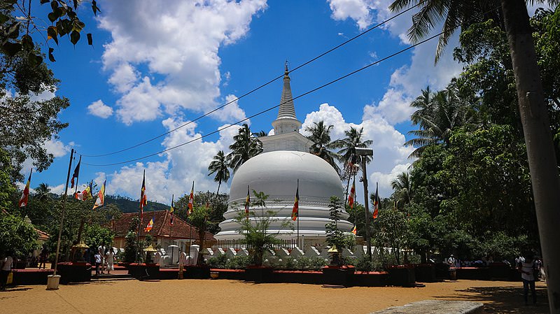
Badulla City
Badulla: Scenic town in Sri Lanka's hill country, surrounded by lush tea plantations and offering picturesque landscapes, waterfalls, and cultural sites.
ナムヌクラ
ナムヌクラは、スリランカの高地の南東にあるウヴァ県の州都、バドゥッラの裏庭の山です。標高 2,035 m のこの山は、スリランカの 12 の最高峰の 1 つであり、西 100 km のシリ パダ(アダムの頂上)からナムヌクラまで続くスリランカ南部山脈の東で群を抜いて高い山です。東にある。ナムヌクラは、バドゥッラに最も近い茶園地帯であるスプリング バレーを支配しています。山の反対側には、ウヴァの別の茶地帯であるパッサラがあります。ウバ茶は、ホートン平原からナムヌクラまでの東西約40キロメートルの全域で栽培されています。カラスが飛ぶように。ナムヌクラは、このウバ茶地帯の最も著名な山です。ナムヌクラ山の高原へ続く道があります。最も簡単なルートは、スプリング バレーとパサーラの間の峠の近くで分岐します。スプリングバレーを通る道は1本しかないので、この峠は簡単に見つけられます。スプリング バレーを走る B97 をデモダラまで進み、スプリング バレーの中心にあるスーパーマーケットのところで左折し、この脇道をほぼ頂上まで進みます。峠の300mほど手前で、左側に登山道が分岐しているのが見えます。この登りに登山スキルは必要ありませんが、間違いなく厳しい急勾配の上り坂です。
森林地帯にはマカクザル、サンバルシカ、イノシシが生息しています。ヒョウはスリランカの森林に覆われた高地にも生息しています。しかし、ハイカーがそれらを見つけることはほとんどありません。直径約 150 メートルの最上部の台地には、釈迦、ヴィシュヌ、ガネーシャの小さな祠があります。スリランカでは、そもそもヴィシュヌ神はシンハラ仏教徒によって崇拝されていますが、ガネーシャ崇拝は主にタミル語です。山岳地帯の南西隅にある尖った高い頂上であるアダムズピークと同様に、この地域を守る山の神もいます。彼の名前はインダカです。バドゥッラでは、このナムヌクラの山の神がブッダをこの地域を訪れるよう招いたと信じられており、これはアダムズ ピークの山の神サマンの物語とよく似ています。アダムズ ピークとは異なり、ナムヌクラにはブッダが残した巨大な足跡がありません。しかし、近くのバドゥッラ町にあるムティヤンガナ ヴィハーラは、仏陀が訪れた 16 か所の 1 つとして挙げられています。紛らわしいことに、ナムヌクラは最高峰の名前であるだけでなく、最高峰から北のバドゥッラ・アンス・ペルガハテンナ峠、南の8キロメートル離れたバレケトゥワ峠まで続くこの山脈全体の名前でもあります。ハエ。ナムヌクラ山脈の南北直径は合計 13 km です。シンハラ語の名前「ナムヌクラ」は「9つの峰」を意味し、この山脈全体を指します。中央高地から見ると、最も目立つ山は円錐形に見え、バドゥッラ地域全体を支配しています。
さらにややこしいのは、上記の脇道の突き当りにある村もナムヌクラと呼ばれることです。エラ - パサラ道路の山脈の南斜面に位置し、エラの東 15 km、バレケトゥワの北東 5 km にあります。これは、まずナムヌクラ村まで車で行き、そこで左折することで、エラからヌムヌクラ ピークに到達できることを意味します。この側道は一般車は通行できないので注意してください。でもトゥクトゥクならなんとかなる。三輪車やバイクでの日帰り旅行に最適です。エッラとパサラ間の道路は美しいですが、ナムヌクラ村とスプリング バレーの間の脇道はさらに壮観です。午前中にヌムヌクラに登った後は、より快適な道を進み、午後にはスプリング バレー、バドゥッラ、ドゥンヒンダ滝、ウバ ハルペワッタ紅茶工場を訪れることができます。スリランカのこの地域の山頂へのハイキング ツアーには、通常、正午と午後の天気が霧や曇りになるため、午前中の時間がよりお勧めです。
Special places in Badulla
-
 Muthiyangana Raja Maha Vihara
Muthiyanganaya Raja Maha Viharaya lies in the centre of the city of Badulla. The History of this temple goes back to the time of Buddha but this area around Badulla goes way back in to the time of 19th -18th century BCE.
-
 Dowa Raja Maha Viharaya
Dowa Raja Maha Viharaya (Dowa Cape Temple) lies few kilometres away from the Bandarawela town on the Bandarawela – Badulla Road. This temple is thought to be done by King Walagamba in the in first century BC.
-
 Bogoda Wooden Bridge
The Bogoda Wooden Bridge was built in the 16th century during the Dambadeniya era. This is said to be the oldest surviving wooden bridge in Sri Lanka. The bridge is situated at 7 kilometres (4.3 mi) west of Badulla.
-
 Dunhinda Falls
Dunhinda Falls is situated about 5 km away from Badulla town. It is 63 meters high and is considered to be one of the most beautiful waterfalls in Sri Lanka. The falls gets its name dew to the smoky dew drops spray.
About Badulla District
Badulla is the capital of Uva Province in Sri Lanka. Badulla is located on the southeast of Kandy, almost encircled by the Badulu Oya , about 680 meters (2200 ft) above sea level and is surrounded by tea plantations. The town is overshadowed by the Namunukula range of mountains. Badulla is about 230km away from Colombo towards the eastern slopes of central hills of Sri Lanka.
Badulla and surroundings are highly recommended for eco-tourists as Horton Plains National Park and the Knuckles mountains are few hours away.
About Uva Province
The Uva Province is Sri Lanka's second least populated province, with 1,187,335 people, created in 1896. It consists of two districts called Badulla and Moneragala The provincial capital is Badulla. Uva is bordered by Eastern, Southern and Central provinces. Its major tourist attractions are Dunhinda Falls, Diyaluma Falls, Rawana Falls, the Yala National Park (lying partly in the Southern and Eastern Provinces) and Gal Oya National Park (lying partly in the Eastern Province). The Gal Oya hills and the Central Mountains are the main uplands, while the Mahaweli and Menik rivers and the huge Senanayake Samudraya and Maduru Oya Reservoirs are the major waterways in Uva province.
【Text by Lakpura™. Images by Google, copyright(s) reserved by original authors.】


