Kandy City
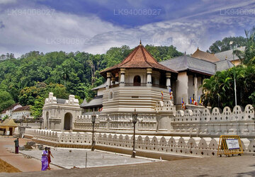
Kandy, a picturesque city in central Sri Lanka, is renowned for its rich cultural heritage, vibrant festivals, and scenic beauty. Nestled amidst lush hills, it is home to the Temple of the Tooth Relic, a UNESCO World Heritage Site, and offers a captivating blend of history and natural splendor.
セイロン・キャンディ最後の王国
キャンディ王国は、スリランカ島の中央部と東部に位置する君主国でした。 15 世紀後半に設立され、19 世紀初頭まで存続しました。
当初はコッテ王国の従属王国であったキャンディは、激動の 16 世紀から 17 世紀にかけて徐々に独立勢力としての地位を確立し、さまざまな時期にジャフナ王国、南インドのマドゥライ ナーヤク王朝、シタワカ王国、オランダ植民者と同盟を結びました。その存続を確実にするために。
1590 年代から、スリランカはスリランカ島で唯一の独立した土着の政治体であり、ひき逃げ戦術と外交の組み合わせによってヨーロッパの植民地軍を寄せ付けず、最終的に 1818 年にイギリスの植民地支配下に置かれました。
王国は1815年のキャンディアン条約に続いて保護国として大英帝国に吸収され、1817年のウヴァの反乱後に決定的に自治権を失った。
長年にわたり、キャンディ王国はさまざまな名前で知られてきました。
- カンダ・ウダ・パスラータ
- センカダガラ王国
- 神田うたらた
- マハヌワラ王国
- スリ ワルダナプラ
- シンハレ
- トゥーン・シンハラヤまたはトリ・シンハラ
- カンデ・ヌワラ
- キャンディ王国
キャンディ王国の領土の多くはスリランカの山と深い森林に覆われた内陸部に位置しており、首都への峠道は防衛側に待ち伏せ攻撃を仕掛ける多くの機会を提供していた。都市へのルートは秘密にされており、それに関する情報を広めることはしばしば死に至る可能性がありました。毎年恒例のモンスーンの時期には丘陵地への多くのルートが通行不能になり、マラリアが蔓延した。キャンディアン軍はその存在を通じてその土地を有利に利用し、侵略軍に対してゲリラ戦を行い[8]、敵軍が近づいた場合には主要都市中心部から避難させた。この戦術はキャンディ戦争中に特に効果を発揮した。王国はバッティカロア港に断続的にアクセスできたが、海軍を持たず、ポルトガルとオランダが低地で強い存在感を維持するのを妨げることはできなかった。
センカダガラプラ市は、ガンポラのヴィクラマバフ 3 世 (1357 ~ 1374 年) の治世中の 14 世紀半ばには設立されたと考えられています。スリランカ中部は、15 世紀初頭から 16 世紀後半までコッテ王によって統治されました。ポルトガルの影響力に直面してコッテが弱体化すると、この地域はセンカダガラプラを首都とする自治領に発展した。 1521 年のヴィジャヤバフの滅亡とその後のコッテ王国の分割に続いて、キャンディは独立を主張し、東王国と南王国に対する深刻なライバルとして浮上しました。
About Kandy District
Kandy district is situated in the centrel province of Sri Lanka. One of the seven World Heritage Sites in Sri Lanka, Kandy was once home to the Kandyan Kings of yore in the 16th-century and a fountainhead for all the music, arts, crafts and culture in the country. About 129 km away from Colombo, Kandy is ensconced amongst a hilly terrain and all eyes are drawn to the centre of the city, where the Kandy Lake forms a charming feature. Kandy retains great religious significance for Sri Lanka, because it is in this charming city that the Dalada Maligawa or "Temple of the Tooth" is located, within which the sacred tooth relic of Lord Buddha lies well guarded.
The Royal Botanical Garden, Peradeniya is situated about 5 km to the west of the city centre at Peradeniya and is visited by 1.2 million people per year. It is the largest botanical garden on the island. The Udawatta Kele (Udawatta Forest) is a protected sanctuary situated in the heart of the city, just north of Temple of the Tooth.
Kandy is a Sinhala majority city; there are sizeable communities belonging to other ethnic groups, such as Moors and Tamils. Kandy is second only to Colombo the center of the Sri Lankan Economy. Many major co operations have large branch officers in Kandy and many industries include textiles, furniture, Information Technology and jewellery are found here. Many agriculture research centers are located in the city.
And a fountainhead for all the music, arts, crafts and culture in the country. About 129 km away from Colombo, Kandy is ensconced amongst a hilly terrain and all eyes are drawn to the centre of the city, where the Kandy Lake forms a charming feature. Kandy retains great religious significance for Sri Lanka , because it is in this charming city that the Dalada Maligawa or Temple of the Toothis located, within which the sacred tooth relic of Lord Buddha lies well guarded.
About Central Provincce
The Central Province of Sri Lanka consists primarily of mountainous terrain. The province has an area of 5,674 km², and a population of 2,421,148. Some major towns include Kandy, Gampola (24,730), Nuwara Eliya and Bandarawela. The population is a mixture of Sinhalese, Tamil and the Moors.
Both the hill capital Kandy and the city of Nuwara Eliya are located within the Central Province as well as Sri Pada. The province produces much of the famous Ceylon tea, planted by the British in the 1860s after a devastating disease killed all the coffee plantations in the province. Central Province attracts many tourists, with hill station towns such as Kandy, Gampola, Hatton and Nuwara Eliya. Temple tooth or Dalada maligawa is the main sacred place in Centrel province.
The climate is cool, and many areas about 1500 meters often have chilly nights. The western slopes are very wet, some places having almost 7000 mm of rain per year. The eastern slopes are parts of the mid-dry zone as it is receiving rain only from North-Eastern monsoon. The Temperatures range from 24°C at Kandy to just 16°C in Nuwara Eliya, which is located 1,889 m above sea level. The highest mountains in Sri Lanka are located in the Central Province. The terrain is mostly mountainous, with deep valleys cutting into it. The two main mountain regions are the central massif and the Knuckles range to the east of Kandy.


